ランタンの旅をまとめ、ポカラへ
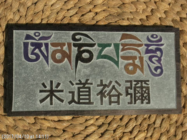
友人の米道裕彌さんの石碑
3月末から4月初めにかけてのランタンの調査を終え、4月11日と12日のSOHAM会議の後に、カトマンズ大学の講義がはじまり半月たった。その間にランタン調査の原稿(下記)を締め切りに間にあわせて投稿したら、時すでに5月を迎えようとしている。歳のせいだろうか、最近は、時のたつのがとくに速いのを感じる。
5月初めには、1年ぶりにポカラに行き、国際山岳博物館の展示の更新をする。その他にポカラでは、懸案の大森さんの大型写真の更新にも目処をたてるとともに、ランタン村でのヒマラヤ災害情報センター構想の実現をめざす活動について国際山岳博物館のネパール側関係者とも相談することに加えて、昨年末に亡くなった友人の米道裕彌さんの石碑*を、すでに祀ってあり、ヒマラヤの神々の座に見守られている友人・先輩たちに仲間入りしてもらおうと思っている。
ネパールでは今年2月後半の余震の後、この2ヶ月間は全く余震のない状態が続いている。その間、地震エネルギーが地下に蓄積されていることを考えると、余震がないことは地下が安定しているのではなく、近い将来の大きな地震発生の兆候だとも解釈できるので、安心はできないだろう。
ポカラへは4月30日にカトマンズをたち、5月7日にもどる、いつものバスの旅になる。
それでは、みなさまもご自愛ください。ナマステ!
(カッコウの歌声が聞こえるカトマンズ大学にて記す)
記
The avalanche sediments of Langtang village and the terminal change of Khimshun glacier-A preliminary report from Langtang excursion for the first time in 20 years-
Hiroji Fushimi
Kathmandu University
Preface
From 27 March to 5 April 2017, I made a short excursion to Langtang village (Fig. 1) suffered from a huge avalanche that occurred at 11:56 on 25 April, 2015, at the time of the Gorkha earthquake and it was my Langtang trekking for the first time in 20 years. Also, I visited Kyanjin (Fig. 1) for measuring the Khimshun glacier that I had once been to the area in 1975. Here, I would like to present a preliminary report of the avalanche sediments of Langtang village and the terminal change of Khimshun glacier, and the related impression on landslide disasters in Langtang valley.

Fig. 1 Google Earth map of Langtang valley with GPS trail.

Fig. 2 The avalanche sediments are seen from Chamki.
1. Avalanche sediments of Langtang village
When I saw firstly the avalanche sediments of Langtang village from Chamki, I was very much surprised to have seen that the avalanche sediments were divided by Langtang river into 5 parts; the main body (AS0) in the right bank and another 4 bodies (AS1-4) in the left bank of Langtang river (Fig. 2-3), and also, each body has ice layers; A and B (Fig. 4).
Right after the Gorkha earthquake 2015, the avalanche sediments covered almost all parts of Langtang village located in the right bank of Langtang river, and also reached to the left bank of the river blocking the river course. The original surface of the avalanche sediments (B0) is detected from the boundary between the grass flank and the debris one along the left bank of the river (Fig. 3 and 8) and the height difference between B0 and the surface of the present B layer is approximately 10m showing the amount of the surface melting during these two years since the occurrence of the Gorkha earthquake, consequently the annual melting rate of the B layer surface is about 5m. So, since the terminal sediment thickness will reach to almost 50m in the middle part of the avalanche sediments observed along Langtang river, the ice layers under the avalanche sediments will be preserved for at least ten years,
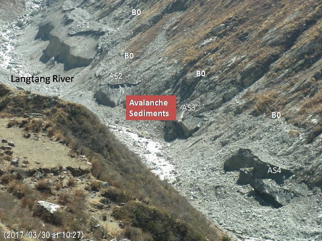
Fig. 3 There are four ice bodies (AS1-4) left at the left bank of Langtang river.
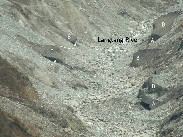
Fig. 4 There are two ice layers A and B observed in the both sides of Langtang river.
The lower ice layer A was formed at the time of the first avalanche occurred on 25 April 2015 when the Gorkha earthquake happened. However I don’t know when the upper ice layer B was formed, since Ito Y, et. al. (2016) reported that it occurred on 12 May 2015 at the time of a large after-shock with magnitude 6.8, but local people denied that nothing happened on 12 May and the second avalanche occurred on 2 May 2015. According to National Seismological Centre, there were a after-shock with magnitude 5.1 reported, so it might be a trigger to cause the second avalanche that formed the lower ice layer B on 2 May 2015.

Fig. 5 Field map of Langtang avalanche sediments with GPS trail

Fig. 6 Panoramic views of avalanche sediments (the upper photos is taken from E, the middle from D and the lower from B points in Fig. 5 and 7).
As local people said that the avalanche sediments itself was now stable and no more rock falls were seen from the huge cliff above Langtang village, so I made a field observation of the avalanche sediments (Fig. 5) and I found that a really vast avalanche sediments cover the entire parts of the past Langtang village (Fig. 6). There are even ponds and river seen on the surface of the sediments (Fig. 7).
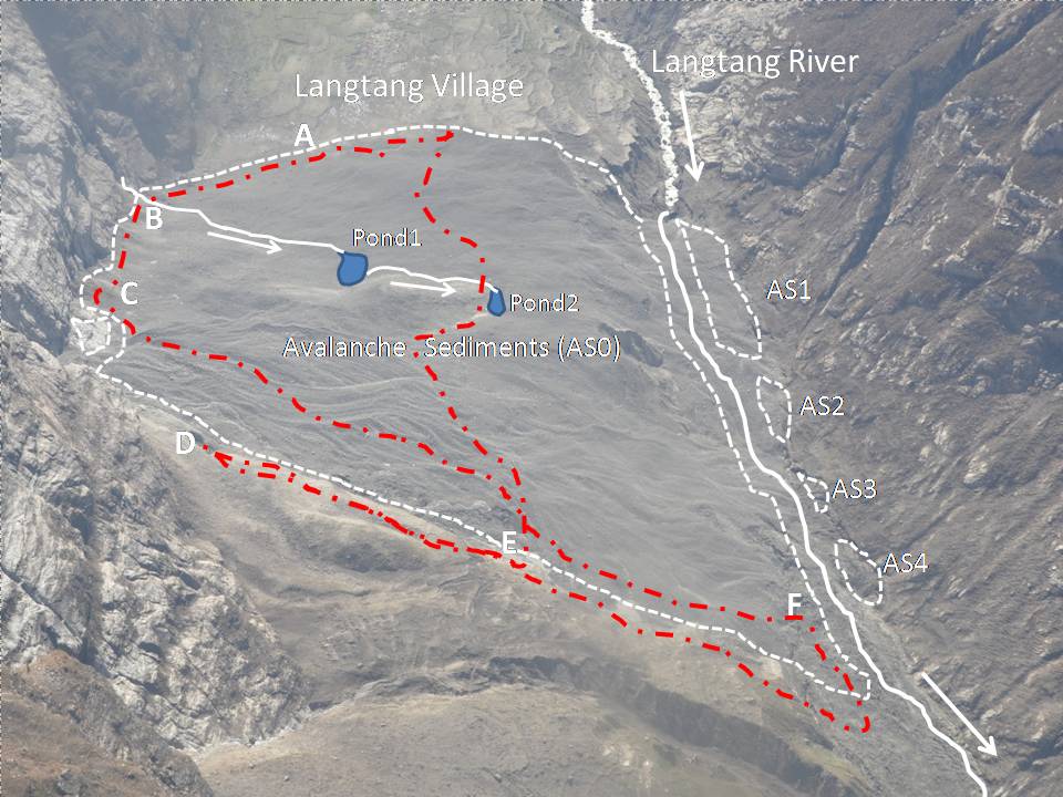
Fig. 7 The field map of Langtang avalanche sediments compiled on the air photo taken by Prof. Yagi K. of Yamagata Univ, on 3 June 2015.

Fig. 8 There is a stratigraphic boundary between A and B ice layer in the ice body (AS4) shown by arrows.
There is a stratigraphic boundary between A and B ice layer in the ice body (AS4) observed at the downstream part of the avalanche sediments in the left bank of Langtang river and it is shown by arrows(Fig. 8), and the B ice layer observed in the ice body AS1 also contains boulders and debris within ice body (Fig. 9).
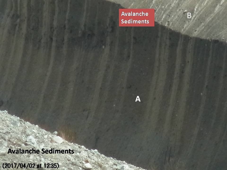
Fig. 9 The B ice layer in the ice body AS1 contains boulders and debris within ice body.
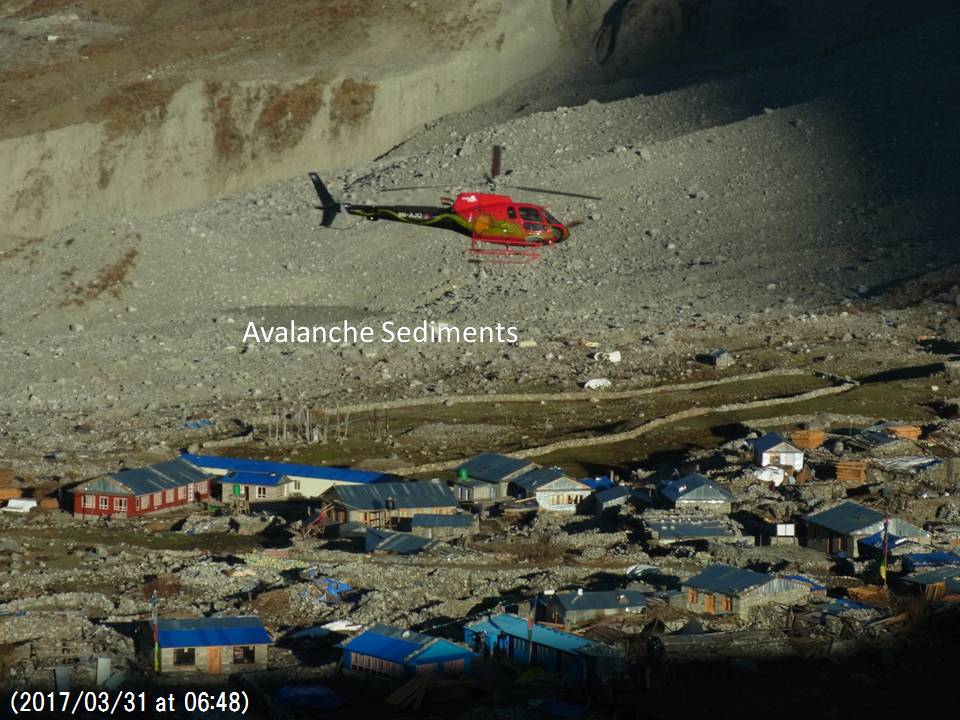
Fig. 10 The recent Langtang village is still under construction of new houses and hotels built very close to the avalanche area.
Though the Langtang people is now eager to construct their houses and hotels in the dangerous area very close to the avalanche sediments (Fig. 10), there are hanging glaciers and steep cliffs in the area of Mt. LangtangⅡ(6596m) and Mt. Langtang Ri (7205m) from where the 2015 avalanche originated and attacked the Langtang village shown by the red arrow in Fig. 11. When a glacial lake will be formed in the 16th century moraine (the upper left photo in Fig. 11), there is a possibility that the so-called GLOF (Glacial Lake Outburst Flood) will occur and attack Langtang village. So, it will be important to monitor a formation of the glacial lake in the 16th century moraine near the hanging glaciers.
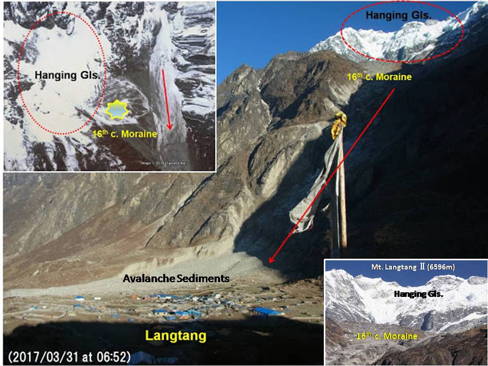
Fig. 11 The 16th Century moraine with hanging glaciers is seen above Langtang village.
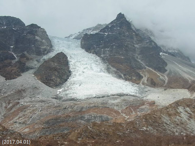
Fig. 12 The present terminal area of Khimshun glacier.
2.Terminal change of Khimshun glacier.
I re-visited the Khimshun glacier in the north of Khanjin on 1 April, 2017 and I found the glacial retreat (Fig. 12). Fig. 13 is the 1975 terminal area of Khimshun glacier with the recent terminal shape shown by red dotted lines. Fig.13 indicates that nearly 100m retreat at the left side and 50m at the central part, but no significant changes observed at the right side.
As far as the terminal changes of the cirque glaciers in Khumbu region such as Gyajo glacier (Fig. 14), the climate warming accelerate glacial retreat with a formation of glacial lakes and a glacier becomes a perennial snow patches showing no glacial flow any more. As the Khimshun glacier is a kind of a hanging glacier having an ice-fall feature, the characteristics of terminal changes may be different from the cirque glacier and also the Gorkha earthquake 2015 might has an effect on the terminal glacier flow.

Fig.13 The 1975 terminal area of Khimshun glacier with present terminal shape shown by red dotted line.
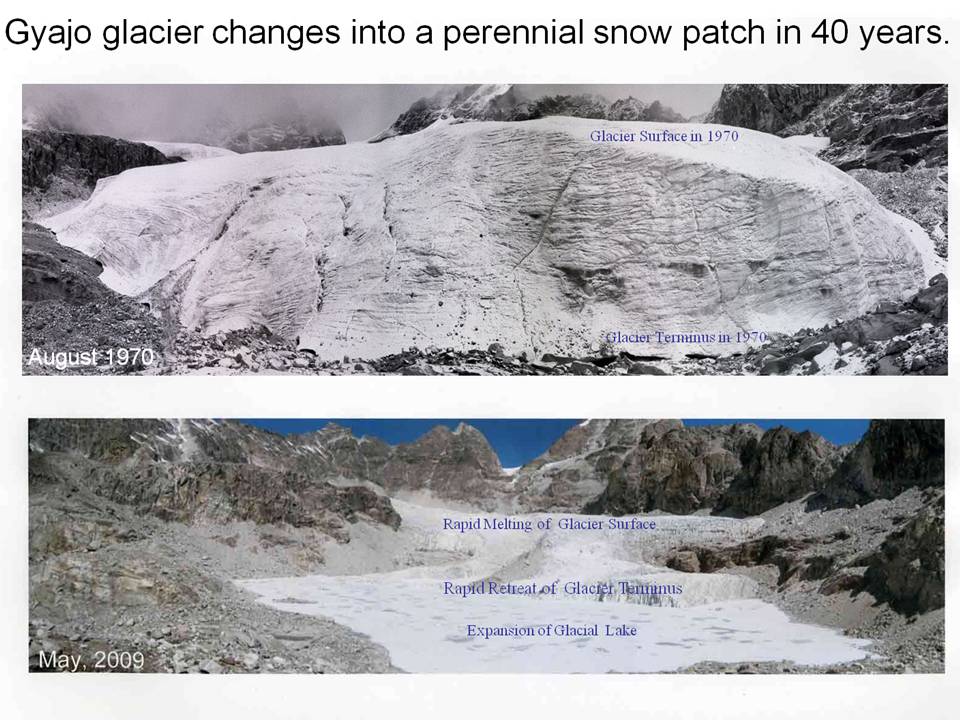
Fig. 14 The Gyajo glacier in Khumbu region changes into a perennial snow patch in 40 years.
3. Landslide disasters in Langtang valley
The Langtang valley close to the capital, Kathmandu, is a center of the sightseeing tourism with beautiful scenery (Fig. 15), however Langtang area has a steep topography of U shaped valley with many talus topography causing frequent rock falls (Fig. 16). Vanessa Banks et.al. (2015) reported that Satellite images north of the Tibet – Nepal border at Nyalam show extensive areas of landsliding and avalanching. At the time of the Gorkha earthquake 2015, many houses were destroyed by rock falls (Fig. 17). There is a high risk of talus rock-falls observed at hotel area of Bamboo showing dangerous topographic situations to stay safely (Fig. 18). The following four pictures show how Langtang villages have been suffered from avalanches and rock falls due to the steep topography and how dangerous valley it is for us to stay safely, We must find out safer places and facilities to stay at the time of Langtang trekking.
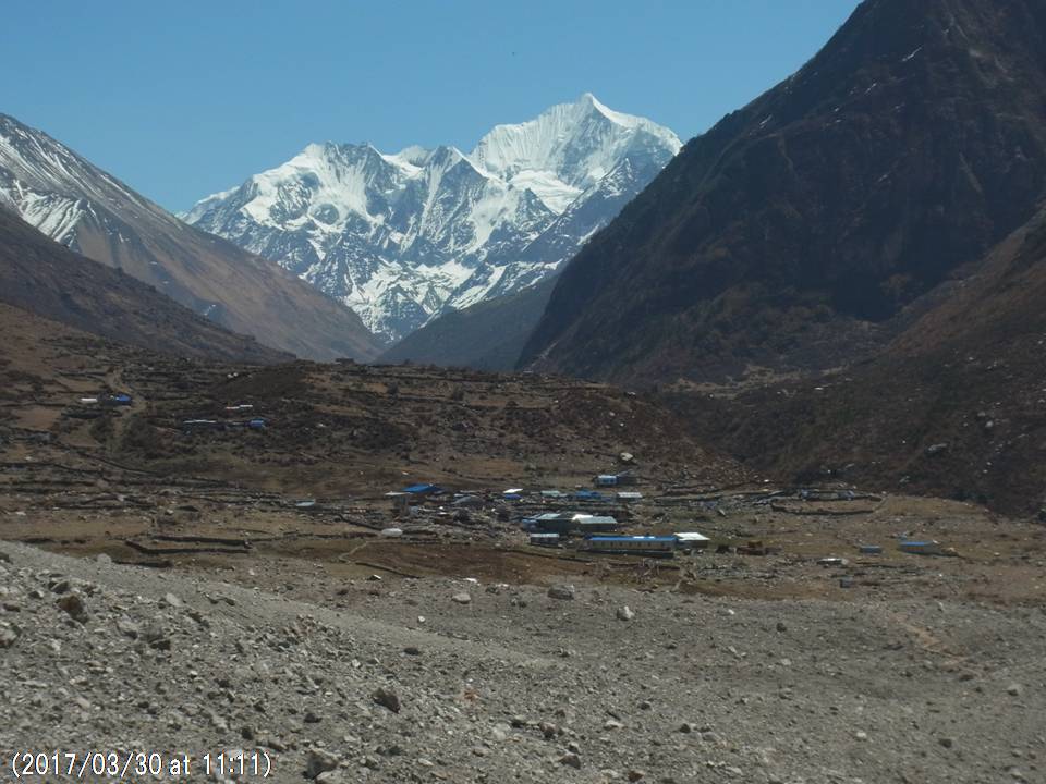
Fig. 15 New Langtang village constructed close to the 2015 avalanche area.

Fig. 16 Newly built hotel in Ghodatabela with talus rock falls behind.
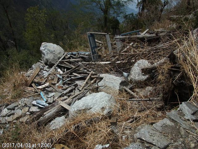
Fig. 17 Local house in Rimche was destroyed by talus rock falls at the 2015 Gorkha.
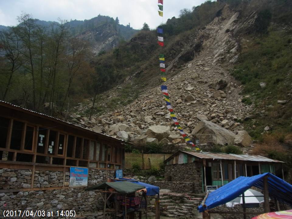
Fig. 18 Dangerous Bamboo hotels influenced by risks of talus rock falls.
References
Ito Y, et. al. (2016) A relationship between the 2015 Nepal earthquake disaster and the depth of snow cover (in Japanese).
National Seismological Centre, Department of Mines and Geology, Recent Earthquakes
http://www.seismonepal.gov.np/index.php?action=earthquakes&show=recent
Vanessa Banks et.al. (2015) Gorkha earthquake in Nepal: a landslide map and update on the landslide hazard.
Acknowledgements
I am very much thankful for Ms. Sadakane A. and Langtang people such as Mrs. Temba Lama, Nima Lama, Dawa Nurpu and Son Nurpu to have informed me about the occurrences of the avalanche sediments when I visited the Langtang valley. Also, I must pay hearty tribute to Drs. Rijam B. Kayastha, Shiraiwa T., Fujita K., Yagi K. and Mr. Sato H. for giving me various kinds of important information in terms of the Langtang avalanches including air photos taken before and after the disaster occurrence.
Supplementation
There was a mountaineering party to Mt. Langtang Ri (7205m), located in the west of Mt. Langtang Lirung (Fig.19), from Osaka City University in April 2015 and one of the member, Mr. Sato H. took valuable pictures of the collapsed summit of Mt. Langtang Ri (7205m) from where the huge avalanche originated and finally attacked Langtang village on 25 April, 2015 right after the Gorkha earthquake (Fig. 20 and 21). This first avalanche must has formed the A ice layer composed of the lower part of the Langtang avalanche sediments already discussed in the chapter 1).
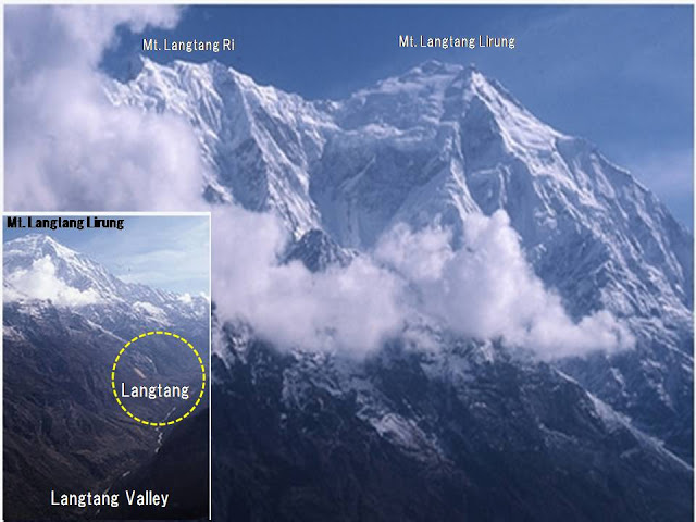
Fig. 19 Air photo shows Mt. Lagtang Lirung, Mt. Langtang Ri and Langtang.
Before Gorkha earthquake, there was a triangular shape of the summit seen from Base Camp for Mt. Langtang Ri (Fig.20), but the summit shape changed largely from a triangular shape to a rugged summit collapsed was seen after the earthquake (Fig.21).
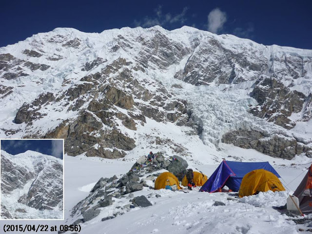
Fig. 20 Triangular summit of Mt. Langtang Ri was seen before the earthquake (This processed photo was taken by Mr. Sato H.).
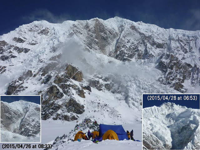
Fig. 21 Rugged summit of Mt. Langtang Ri collapsed was seen after the earthquake (This processed photo was taken by Mr. Sato H.).